
Cedar Creek
BaldwinExposure: Mixedfaces east
Lake Sinclair
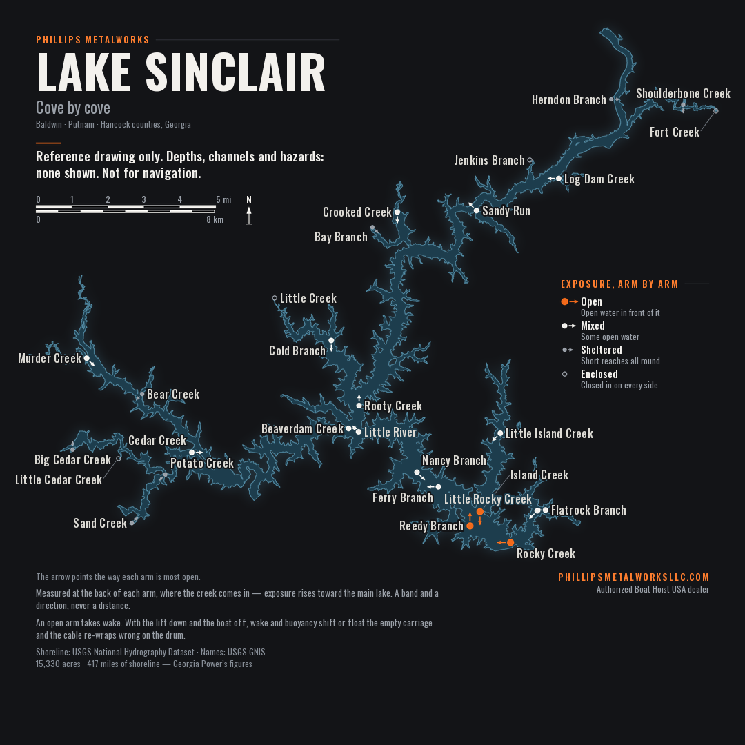
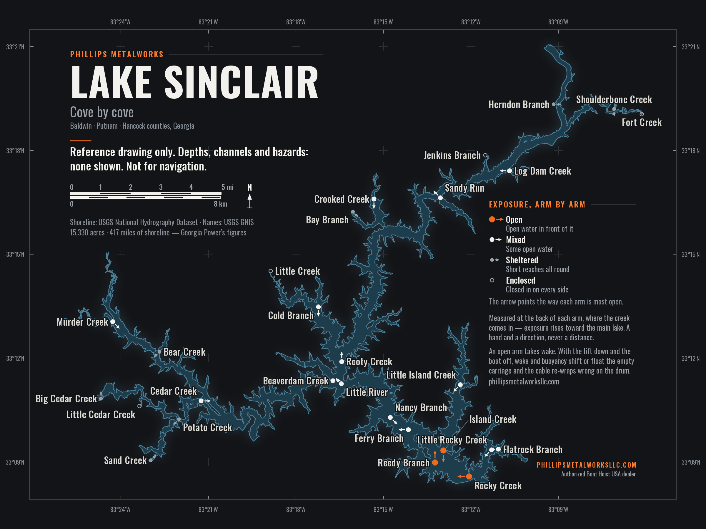
Fifteen thousand acres, four hundred miles of shoreline and forty islands. The drawing below is from the federal survey of the lake. Every creek arm below is one the Oconee drowned in 1953 — which is why the coves here are shaped like creeks, and why the water reaches so far up so many of them.
This is a reference drawing, not a chart.
It shows no depths, no channels, no shoals and no hazards, and the shoreline is drawn at full pool — the water is lower than this for part of most years. Nothing on this page should be used to navigate. A cove drawn wide is not deep water, and an island drawn small is not a small island.
The survey marks each creek at the back of its arm — where the creek comes in, which is the most sheltered water on it. The word against each name below is exposure there, at the back: how much open water has a straight line to that point, and from which direction. It rises from there toward the lake, so a dock nearer the mouth sits in more open water than the word says, as a rule, not less.
What that means for a lift is our reading, from the lifts we work on, and not something the survey knows: an open arm takes wake off the main lake that an enclosed one does not. With the lift down and the boat off it, wake and buoyancy shift or float the empty carriage, the cable goes slack, and it re-wraps wrong on the drum. The cure is weight — weight the carriage, or add cable weights — and the cost of leaving it is cable that wears where it was never meant to, which is how an open arm ends up on the cable page.
Exposure is one of the things the ground decides for a lift on this lake. Another is how far the power has to come, from the panel at the house to the motor on the dock, and that one is arithmetic: the wire size calculator does it for your run.
The names are the official ones, and each arm is listed under the county its water sits in. If you know an arm we have called sheltered that takes wake all summer, or one we have called open that never does, tell us and we will look at it.
The direction is the one the back of the arm is most open to. It is given for mixed and open arms; on a sheltered or enclosed arm there is too little open water for the direction to mean anything.
How we worked this out. From the point where the survey puts each creek mouth, we cast lines of sight across the water in eight compass directions — a fan of thirteen in each, spread across ninety degrees — and stopped every line at the first shoreline or island it met. The average length of a fan is how far open water reaches that point from that direction, and the longest of the eight sets the band. Lines that ended at either dam were thrown out, because the survey polygon is cut off there and a line stopping at a data edge has not met a bank. Where the survey placed a mouth a short way up the bank, the measurement starts at the first water below it. The lines between the bands are fixed in advance, from how far a wave needs to run across open water to build to a given height, and not from this lake’s own spread — so anyone who repeats the arithmetic on the same shoreline gets the same bands. They rank each arm against one yardstick; they are not a measurement to take onto the water, which is why no distance is printed. It is shoreline geometry only: it knows nothing about what is built either side of a dock, and it cannot see yours. Shoreline from the USGS National Hydrography Dataset; the arithmetic is ours.
It is the question we get asked most about the water itself, and the honest answer is that no authoritative figure exists for any bridge on Lake Sinclair.
Vertical clearances are recorded where a waterway is under federal navigation control. Lake Sinclair is a private reservoir — Georgia Power built it and owns the shoreline — so it has no nautical chart and no published clearance table. Georgia’s boating law has something to say about bridges — idle speed within a hundred feet of any bridge structure or abutment — and nothing at all about how much room is under one.
There is a second reason, and it is the one that matters more. Clearance on a reservoir is not a fixed number. It is the gap between the bridge and the water, and the water moves — through the day, and by several feet in a drawdown. A figure that was right in July is wrong in November, so even a measured number would mislead somebody eventually.
So we stop short of a number. If you are moving a boat with a tower or a hard top and the gap looks tight, the only reliable answer is to go and look at it at the level it is that day.
Geography does more work on this lake than most people expect, and it shows up in three places. Then there are the two things that decide a lift anywhere: what it hangs from, and what it is holding.
A cove with a mile of open water in front of it takes wind and wake that a tight creek arm never sees. With the lift down and the boat off it, it is the wake that shifts an empty carriage — and a carriage that shifts, or that has dried out enough to float, is how cable ends up wrapped wrong on the drum.
Boathouses sit at the end of the property, and the panel is at the house. On the long lots common up the creek arms, that run is where the voltage goes — and a motor fed thin wire struggles at the worst possible moment, with the boat on it.
Georgia Power does not permit free-standing boat lifts here, so a lift hangs inside a boathouse — and whether you can have a boathouse at all comes down to a house already being on the lot and how much straight shoreline it has.
The pipe hangers typically hang from two header beams, and the gear plate usually mounts to a third, smaller header at the front — timber more often than not, and on an older boathouse sized for a roof rather than a roof and a boat. What those headers are, and what the posts under them are doing, settles whether a lift can go there at all, and which one, before the boat comes into it.
The plate and the motor come from the weight; the brackets come from the hull, and they are not the same decision. A pontoon lifts from the tubes on low-rise brackets or from the floor on risers, which are different things. A V-hull or a wake boat sits on bunks. A personal watercraft runs on its own small brackets. The right lift on the wrong brackets is holding the boat the wrong way.
Sinclair Dam closed the Oconee River in 1953, backing water up the river and into every creek that fed it. The counties around the lake are Baldwin, Putnam and Hancock. Figures are Georgia Power’s and are given as published; the shoreline mileage in particular is a coastline measurement and varies with how finely it is walked.
The state boating rule for this lake names its bridges, and the names are how people here say where a place is — above the Little River bridge on 441, past Twin Bridges, the far side of the trestle. That is the whole of what they are doing on this page. Why there is no number for any of them is set out above, and it is not going to change.
One of those is not a road. The trestle is a railroad, and railroad property, not a public crossing. It is on this map because it is a landmark everybody navigates by — not because it is somewhere to tie up, fish from, or go near.
Names are as they appear in Ga. Comp. R. & Regs. 391-4-5-.20, the state rule that lists them; the rule’s first item, Taylor Creek Bridge on GA 212, is one of the two places GA 212 crosses the water and both are drawn. Positions come from the Federal Highway Administration’s bridge inventory and the USGS road and rail lines, checked against the shoreline; they are landmarks, not a survey.
The public launch sites on Lake Sinclair, as recorded by Georgia DNR, as of July 24, 2026. Name, county and where it is, and nothing else — because nothing else about a ramp is ours to say.
| Ramp | County | Where |
|---|---|---|
| Rocky Creek | Baldwin | Near Little Rocky Creek |
| Seabrook Road | Baldwin | Near Little Rocky Creek |
| Cosbys Landing | Hancock | Near Little Island Creek |
| Upper Sinclair (SR16) | Hancock | Near Herndon Branch |
| Dennis Station Access Area #1 | Putnam | Near Beaverdam Creek |
| Dennis Station Access Area #2 | Putnam | Near Beaverdam Creek |
| Lake Sinclair Recreational Area | Putnam | Near Murder Creek |
| Oconee Springs Park | Putnam | Near Jenkins Branch |
| T D Cheek Public Fishing Area | Putnam | Near Beaverdam Creek |
We do not run any of them. Whether a ramp is usable on any given day depends on the pool and on maintenance, and we check neither. The lake moves through the day and a ramp is poured at one level — the same reason a lift gets set for the low water rather than for the afternoon it went in. What the level does →
If a ramp is not obviously public, treat it as private. Most of the concrete going into this lake belongs to somebody.
Source: Georgia DNR Wildlife Resources Division, interactive boating map. DNR has not checked this page, and a ramp being listed here is not an endorsement of it. No fees, hours, phone numbers or open-or-closed status, because they change and we do not track them.
A working reservoir first and a place to live second, and both show in the dates.
Dates are as recorded by the agencies and companies involved; the choosing is ours. The old river course is not drawn on the map above, on purpose — a line where the river ran is a statement about the bottom of the lake, and this page does not make those.
The creek names on the drawing are the official ones. The names people actually use are not written down anywhere — not in any public dataset, not on any chart we are allowed to copy. If we have a cove marked with a name nobody says, or we have missed one that everybody knows, tell us and we will fix the map.
Call or text and talk to someone who actually does the work. No call center, no ticket number.
That number takes texts. Prefer to write? contact@phillipsmetalworksllc.com